|
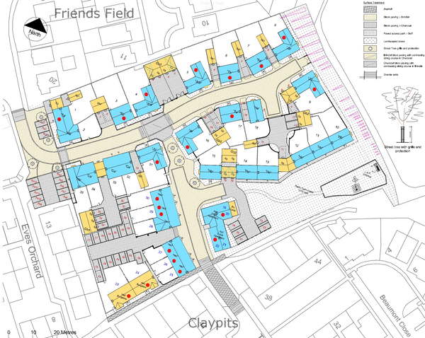
The land is approximately
3.5 acres and will now accommodate 35 properties on this development.
That works out at 0.1 acres per household
|
Planning Application
B/13/00074
dated 22/01/2013
Former Cottages and Packing Sheds, Eves Orchard
Application for Advertising Consent - erection of a single Sales
Board and 4 Flag Poles
Applicant:-Persimmon Homes
|
Planning
Application B/13/00078
dated 22/01/2013
Former Cottages and Packing Sheds, Eves Orchard
Change of use to temporary
sales area including a site office for a period of 1 year
Applicant:-Persimmon
Homes
|
29th May
2012
Charles Church already advertising this development on their web site.
Listed as "Braeburn Gardens"
Braeburn is a variety of apple, chosen no doubt after the orchard on which
site the development is to take place
Pity Persimmon didn`t pick an english apple variety
to represent an English orchard
(Braeburn was discovered in 1952 by the farmer O. Moran from Waiwhero
in the Moutere Hills near Motueka, New Zealand.)
Final Plans
accepted by Babergh
Soil Test results by Richard
Jackon Intelligent Engineering of Hadleigh
Extract taken from a 63 page document
5.3Risk Assessment
From the above, it is evident
that the U95 value for benzo(a)pyrene
( derivative of coal, fossil fuels etc) of
1.126 mg/kg is greater than the screening value of 0.89 mg/kg. However,
in this case, the Tn value is greater than the Tcrit value indicating
that the highest value is not consistent with the underlying data set
and should be treated as a ‘hotspot’.
Considering initially end
users of the site, exposure to contaminants would be through dermal contact
or ingestion or inhalation of contaminated soil where soil is exposed,
such as in gardens or areas of landscaping.
There is considered to be no risk beneath buildings and paving as in such
areas there is no pathway by which the pollutant linkage may be completed.
Plans provided indicate TP4 to be located under hardstanding, whilst TP1
is located in a garden area. Remediation is therefore considered necessary.
It is recommended that further limited investigations are carried out
prior to remediation proposals being finalised in order that the extent
of the contamination can be established.
Soil Contamination and Construction Workers, Maintenance Workers and the
Public:
Risks to site workers and site neighbours during
redevelopment are again primarily through dermal contact, ingestion and
inhalation of contaminants. It is considered that the degree of contamination
observed poses a low risk to site workers and a very low risk to site
neighbours.
In order to reduce the risks of site workers during redevelopment, safety
measures should be adopted on site.
Workers should avoid contact with the soil by the use of protective boots,
overalls and gloves, and should wash before eating, drinking and using
the toilet.
To prevent inhalation of contaminants by site workers and wind blown transfer
of contaminants off site, the generation of dust should be avoided, this
may be achieved by spraying the materials with water if necessary. Measures
should be taken to ensure that contaminated materials are not accidentally
transferred off site, for example on vehicle tyres.
It is considered very unlikely
that the levels of benzo(a)pyrene encountered will have an effect on the
underlying secondary aquifer. Furthermore, elevated levels in garden areas
will be remediated against, whilst in other areas the contaminants will
be covered by hardstanding, which will significantly reduce the potential
for downward leaching of the contaminants. It is also considered very
unlikely that the water table will rise to a level sufficient to come
into contact with any contamination.
Therefore there is considered to be no significant risk to the secondary
aquifer below the site.
5.4 Hazardous Gases
Given the presence of Made Ground to a depth of 2.8m, with organic matter
within this Made Ground, it is considered that hazardous ground gases
may be produced.
Ground gas monitoring should therefore be undertaken to assess this risk
Extract from Suffolk
Free Press 28th
May 2012
Newspaper headline reads:-
Councillors give Bures protests short shrift
The construction of 35 new homes in Bures
has been granted permission – despite the protests of villagers.
Proposals to build a variety of properties,
including flats, bungalows and houses, on a site south of Friends Field
went before a development committee at Babergh District Council on Wednesday.
Although a combined total of 115 residents
from Friends Field, Claypits Avenue and Tawneys Ride had signed two petitions
outlining their grievances with the development, the plans were approved.
Bures District Councillor Peter Holbrook
opposed the plans, citing over development, along with parking and traffic
issues.“I wasn’t happy with the decision,” said
Mr Holbrook.
“I am not against the principle because the site has been allocated
for housing but the primary school is already at capacity and the roads
around the school get clogged up.
“There is insufficient
parking on the development and this will cause big problems in other parts
of the village.”
Bures Parish Council had objected to the
plans on the grounds of increased congestion and advice from the Suffolk
Wildlife Trust that the site may be of ecological interest.
Parish councillors also argued that the
positioning of the 12 affordable houses on the development, next to another
area of affordable housing in Tawneys Ride, gave the impression of a “ghetto
area”.
Mr Holbrook, who lives in Croftside, Bures,
said these views should have been given more weight by the ruling committee.
“For 115 people to sign these petitions
is a very big percentage in a small village,” he said.
“There are problems with access
to Tawneys Ride due to the presence of garages – a recipe for disaster
with people reversing into the path of speeding cars.”
The plans, which were submitted by property
development company Charles Church, were approved subject to the completion
of a section 106 agreement – money to offset the impact of the development
– and under the provision the homes are built within the next three
years.
Work is due to start this summer and the
first homes are expected to be ready later this year.
===========================================================================================
May 16th 2012
Babergh Development Committee granted planning
consent to build 35 homes on this land.
This was despite 115 objections mainly concerning access and traffic along
already congested roads.
Bures St Mary Parish Council opposes these plans on Highways, Road Safety
and School concerns.
It would appear that the traffic problems didnt warrant any discussion
at the meeting.
NOTE:- The committee members listed
below, who have our interests at heart !
With these councillors representing wards
such as Chelmondistan, Brantham, Copdock, Holbook, Bentley, Lindsey etc
what possible interest have they in our congested village.
Well done to our own Councillor Peter Holbrook, for speaking out against
this development.
Babergh Planning Committee Membership
* C W Arthey.....Lindsey, IPSWICH
* M F M Bamford........Bentley IPSWICH
* P K Beer (Chairman).... Broom Street, Great Cornard
* M J Deacon..........Chelmondiston
* K Grandon.........Hadleigh
* P J Holbrook............BURES, ..................STRONGLY
OBJECTED TO PLANS - excellent
* P Jones............Copdock and Washbrook
* D H Keane............Bildeston,
* N MacMaster............Great Cornard
* M O Munson.............Hadleigh
* A F D W Osborne...........SUDBURY
* D C Rose............Holbrook,
* R C Smith...........SUDBURY
* R W Thake..........Glemsford,
* A J Ward...........Brantham, MANNINGTREE
|
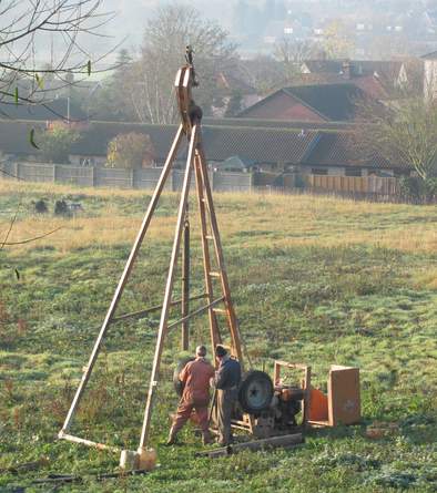
|
Soil test rig late 2011
Richard Jackson of Hadleigh.
See above for test results
|
|
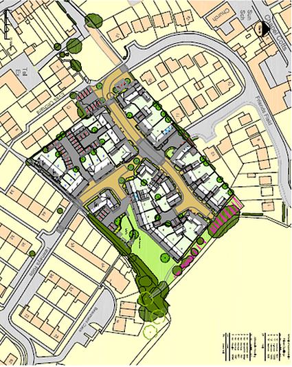
Eves Orchard Plans,
August 17th 2011
Site Meeting in Friends Field with representatives from Babergh
Planning Committee and the Highways Authority.
(Seemed to spend no time whatsoever looking at the congested
access and poor visibility into Friends Field.
Totally
ignored residents in the road - hadn`t the common courtesy even
to acknowledge our existance)
August 9th
2011
Bures St Mary Parish Council opposes these plans on Highways, Road
Safety and School concerns.
July 30th
2011
Local residents receive details of the planning application from
Babergh District Council.
July 27th
2011
Application now listed on Babergh Web Site
July 5th 2011
Charles Church Homes
(Division of Persimmon Homes) formally submit an application to
Babergh to develop the land to the rear of Friends Field.
This will consist of 23 private properties and 12 affordable houses,
making a total of 35.
Application No. B/11/00825
 Building
Design Building
Design
Development
layout ( larger image than >>>>>)
|
|
|
Once again in Mid
2004, this plot of land was once again been put forward
as a possible site for housing development.
This time however, Babergh District Council have elected to place
this area in their "Local Plan" suitable for housing.
Although this was tentatively
supported by the local Parish Council, very few residents agreed
with this change of use, all were concerned by the restricted access,
density of the housing and school overcrowding.
Residents were once
again asked by Babergh for their comments, prior to the Local Plan
Public enquiry.
When the Inspectors report and comments were quoted back to them
from 1988/9, the reply given by the District Council was that these
were now "invalid objections"
The conclusion reached by Babergh was that:- "The Inspector
is asked to make no changes in the light of all of these objections"
The District Council readily agreed with the Planning Inspector
in 1988, but now disagree with him when they are clambering for
land.
During September/October
2004, there was the Public Enquiry where the Government Inspector
decided in favour of the District Council.
It has now been included in the Local Plan as land suitable
for housing development
Extract from EADT/Suffolk Free
Press
|
|
Planning
Application B/933/88
In 1988. developers (Vaughan
and Blyth, Colchester) applied for planning permission to erect
19 properties on this land. Objections were made by the residents
and the parish council.
Babergh District Council
refused this application on the grounds:
(a)The Site is located
outside the built-up limits of the village as defined in the Planning
Guidlines. This states that land uses will remain for the most part
undisturbed and applications for residentional development will
not normally be approved.
(b) The proposal represents an undesirable extension to the built-up
area in the countryside which if permitted would be to the detriment
of the character of this local village, in addition it would also
create a precedent for similar proposals and would adversely affect
the satisfactory pattern of development in this locality.
(c) The site lies within the potential extension to the Dedham Vale
AONB which also lies within the Stour Valley Special Landscape Area.
where the Council seeks to safeguard the landscape .........
.
(d) Visibilty at the junction of Friends Field with Cuckoo Hill
is substandard and results in Traffic dangers
Vaughan Blyth then
went to an appeal.
The HM Planning Inspector
again refused this application. The Inspector agreed with all the
refusal reasons given by Babergh in addition to these additional
comments:-
(a)" .....the
site lies within the Bures conservation area adjacent to its eastern
edge and being densely populated with fruit trees it represents
in my view an important visual feature and one which fulfills a
worthwhile transitional function between the neighbouring housing
and the open countryside. As such, it seems to me to be a detrimental
element in the pleasnat semi-rural character and apperance of an
otherwisw relatively unremarkable part of the conservation area
and the village...............................................
(b) Babergh also
refer to the lack of adeqaute visibility at the junction of Friends
Field and Cuckoo Hill, any increased usage would cause traffic dangers.
..........in the absence of any further information that the juction
could be improved without spoiling the rural appearance of this
part of Cuckoo Hill, I see this as another defect of the appeal
proposal
Full
Report
After this, harmony was restored and
the orchard once again flourished with its magnificent display of
pink apple blossom, that could be seen from miles around.
ISSUE 2
Documents from Babergh DC
|
|
|
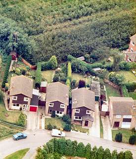
Orchard to
the rear of Friends Field circa 1980
(Courtesy of Aerial Scenes, Earls Colne
Airfield) |
|