|
In 855
AD records document the crowning of St Edmund at Burva, consequently we
can assume, that Bures was an area with a substantial holding of land.
A foot or horse bridge would have existed during that period.
The Doomsday
records of 1086 indicate the existence of a "Church with 18 acres
of free land", again this would make a bridge essential to maintain
the surrounding fields.
During the 11th -16th century, the Church, surrounding lands and the ownership
of the bridge came under the jurisdiction of the Stoke by Clare Priory,
In 1574 the Priory was dissolved and the ownership of the bridge passed
into private hands.
Until the 17th century Bures was predominately a Suffolk village with
very little housing on the Hamlet side.
The bridge up to this
time, fell into disrepair on many occasions with the owners never willing
to spend any money on repairs. Finally in the 17th century, the bridge
was completely rebuilt with a wooden construction.
November 6th 1762 (Reported in Ipswich
Journal newspaper)
Bures bridge, near Sudbury has been washed away by the violence of the
flood on Tuesday last. Notice is hereby given that no wheeled carriages
can pass over the river Stour at that place. A new bridge will be erected
as soon as possible.
| In
1881 it was once again rebuilt, but this time replaced by cast iron.
The majority of the framework was cast at a foundry in London and
somehow transported to Bures for construction. The river, via Mistley
being the most likely mode of transport. |
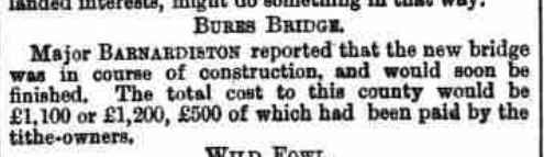 Bury Free Press January 15th 1881
 |
The Hamlet side, even
up to the early 1900`s was the home of the poorest and lowest paid workers
who were supported by the Sudbury Union Workhouse. Wealth was effectively
on the Suffolk side.
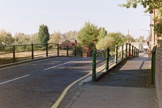
The bridge carries the B1508, main traffic route between Colchester to
the South and Sudbury to the North.
The source of The River Stour rises at Carlton near Haverhill and continues
through Clare, Sudbury, Bures, Nayland, Stratford, Dedham, Flatford onward
to Manningtree where it becomes tidal at Cattawade Bridge.
It continues it`s seaward journey past Mistley joining up with the River
Orwell at Harwich.
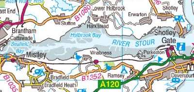
The river also serves as the county boundary between Suffolk (Sturmer,
Nr Haverhill)
and Essex (Harwich)
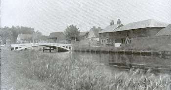 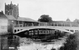
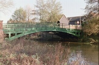
These photographs taken
nearly 100 years apart, show little has changed in its appearance. On
the top two photographs the wharf can clearly be seen to the right of
the bridge, where the barges were berthed.
A regular inspection
of all bridges in Suffolk is undertaken every two years and it was at
one of these visits in mid 1990, that cracks were found in the supporting
structure. The bridge has a 20 metre span of five cast-iron supports interconnected
by brick arches, a typical design of the Victorian era.
Cast iron has advantages, it`s cheap and quick to produce and ideal for
basic bridge construction. Commonly used by the Victorians.
However all cast iron has one major drawback, it suffers from fatigue,
fractures and fails quickly.
As the cracks were on the load bearing girders, directly under the carriageway,
an immediate weight restriction of 3 tons was placed on the bridge in
addition to traffic lights.
The bridge built at the beginning of the 1900`s was never designed to
carry the size and weight of vehicles, that we today, take for granted.
This caused severe disruption to HGV and public transport. Chambers rerouted
their buses via Nayland Rd and Smallbridge Hall, a hazardous and very
narrow route.
Unfortunately for those living on the Essex side such as Normandie Way,
their bus service suddenly vanished.
Local farmers found themselves unable to cross the bridge with their farm
vehicles to gain access to other fields and buildings.
Unfortunately not everyone was so law abiding - visiting HGV`s continued
to cross the bridge in spite of the warning signs, in order to avoid a
lengthy diversion.
Many options of repair were considered:-
(a) Strengthening - problems with services and river below.
(b) Reconstruction - not cost effective at approx £500,000
(c) Temp Bailey Bridge - no viable access on approaches
(d) Reinforcing cast-iron ribs with steel plates - untried.
The situation remained
like this for several months whilst the County Council considered other
alternative methods of repair.
It was decided to employ a new technique of epoxy-resin bonding, which
is literally glueing the bridge back together. Laboratory and field tests
were carried out on the remains of a cast-iron bridge from Preston St
Mary. As this was successful Suffolk County Council and its main contractor
decided to go ahead. (Click Here for a
detailed explanation)
On 12th October 1991
the bridge was reopened and normality returned to the village with traffic
once again flowing normally.
(Information source SCC/contractor)
|
View
from bridge looking towards Suffolk
|
View
from bridge looking towards Essex
|
Information obtained
from:-
SCC/ECC Records Office
Stoke by Clare Priory Web site
|